30MILES Reitit

30MILES Routes

free site creation software
Mobirise

Takaisin pääsivulle (Back to main page)

Tärkeää

Nämä esimerkki reitit on tarkoitettu ainoastaan tukemaan reittisuunnittelua 30MILES-satamien välillä. Reitit on suunniteltu parhaan käytettävissä olevan tiedon pohjalta alkuvuonna 2017. XAMK ei kuitenkaan ota vastuuta reittien turvallisuudesta, vaan näiden käyttö on omalla vastuulla. Aluksen päällikkö on aina vastuussa turvallisesta reittisuunnittelusta ja reitin suunnittelussa tulee huomioida viimeisin ja paras tieto reittiä koskien. On tärkeää huomioida, että näitä reittejä ei päivitetä jälkikäteen, joten mahdollisia reittien tekemisen jälkeen tapahtuneita muutoksia ei ole huomioitu.

Lyhyet ohjeet

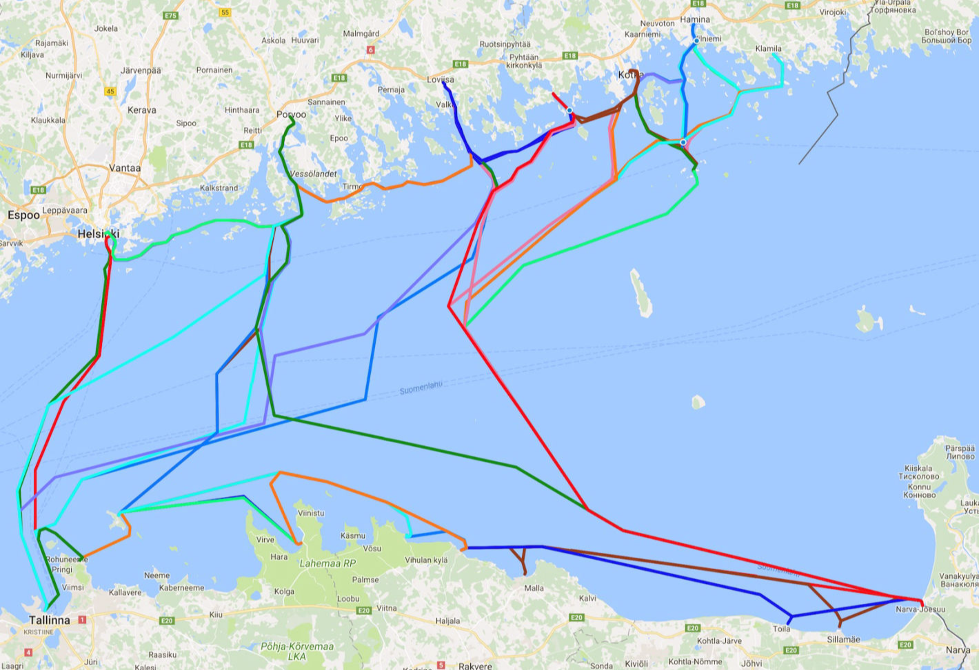
30MILES reittiverkostoa voi tarkastella kokonaisuutena tai yksittäisinä reitteinä Google Mapsissa klikkaamalla reitin perässä olevaa linkkiä. Google Maps on tarkoitettu vain reittien esikatseluun, lataa alkuperäiset reitit tältä sivulta. Reittipaketti sisältää kaikki alla listatut reitit. 

Kaikki 30MILES reitit kartalla

Reitit ovat saatavilla gpx-muodossa ja ne on pakattu yhteen zip-pakettiin. Voit ladata reirit klikkaamalla alla olevaa linkkiä oikealla painikkeella ja valitsemalla "Tallenna nimellä". Reitit on suunniteltu käyttäen OpenCPN-ohjelmaa, joka on useille alustoille saatavissa oleva avoimen lähdekoodin karttaohjelmisto.

Lataa koko reittipaketti

Important!

These example routes are aimed only to aid in route planning between 30MILES harbors. Route planning has been done with the best information available at the beginning of the year 2017. However, the information presented here is to use solely at your own risk. XAMK or authors take no responsibility for the safety of the routes presented here. Captain of the vessel is always responsible for the safe route planning and to take into account the latest and best available information concerning the route. Keep also in mind that these routes are not updated afterward, and later changes are not taken into account. 

Brief instructions

It is possible to see the whole 30MILES route structure or view routes individually on Google Maps by clicking 'View'. Google Maps is only for previewing routes, download actual route files from below. The route packackage includes all the routes listed below. 

All 30MILES routes on a map

Route examples are provided in gpx-format and packed in one zip-package. To download these, please right click appropriate link and select 'save as'. Routes are planned with OpenCPN which is a free open source chartplotter for multiple platforms.

Download the whole route package.

  • Eisma Port - Kelnase Port  View
  • Eisma Port - Narva-Jõesuu View
  • Eisma Port - Safety harbour Kunda - Safety harbour Sillamäe - Narva-Jõesuu  View
  • Eisma Port - Safety harbour Vergi View
  • Eisma Port - Safety Port Loksa View
  • Eisma Port - Safety port Toila (vessel draft max 1,4 m) - Narva-Jõesuu View
  • Haapasaari Coast Guard, Passport Station - Hamina Tervasaari Port View
  • Haapasaari Coast Guard, Passport Station - Klamila Port View
  • Haapasaari Coast Guard, Passport station - Kotka Old Port View
  • Haapasaari Coast Guard, Passport Station - Narva-Jõesuu View
  • Hamina Tervasaari Port - Haapasaari Coast Guard, Passport Station View
  • Hamina Tervasaari Port - Klamila Port View
  • Hamina Tervasaari Port - Kotka Old Port View
  • Hamina Tervasaari Port - Narva-Jõesuu View
  • Helsinki Katajanokka Guest Harbour - Lennusadam, Tallinn View
  • Helsinki Katajanokka Guest Harbour - Porvoo Guest Marina View
  • Kelnase Port - Eisma Port View
  • Kelnase Port - Porvoo Guest Marina View
  • Kelnase Port - Safety harbour Loksa View
  • Kelnase Port - Safety harbour Vergi View
  • Kelnese Port - Leppneeme Port View
  • Klamila Port - Haapasaari Coast Guard, Passport Station View
  • Klamila Port - Hamina Tervasaari Port View
  • Klamila Port - Narva-Jõesuu View
  • Kotka Old Port - Haapasaari Coast Guard, Passport station View
  • Kotka Old Port - Hamina Tervasaari Port View
  • Kotka Old Port - Narva-Jõesuu View
  • Kotka Old Port - Pyhtää Keihässalmi View
  • Lennusadam, Seaplane - Leppneeme Port View
  • Lennusadam, Tallinn - Helsinki Katajanokka Guest Harbour View
  • Lennusadam, Tallinn - Loviisa Laivasilta View
  • Lennusadam, Tallinn - Porvoo Guest Marina View
  • Leppneeme Port - Kelnese Port View
  • Leppneeme Port - Lennusadam, Seaplane View
  • Loviisa Laivasilta - Lennusadam, Tallinn View
  • Loviisa Laivasilta - Narva-Jõesuu View
  • Loviisa Laivasilta - Porvoo Guest Marina View
  • Loviisa Laivasilta - Pyhtää, Keihässalmi View
  • Narva-Jõesuu- Eisma Port View
  • Narva-Jõesuu - Haapasaari Coast Guard, Passport Station View
  • Narva-Jõesuu - Hamina Tervasaari Port View
  • Narva-Jõesuu - Klamila Port View
  • Narva-Jõesuu - Kotka Old Port View
  • Narva-Jõesuu - Loviisa Laivasilta View
  • Narva-Jõesuu - Porvoo Guest Marina View
  • Narva-Jõesuu - Pyhtää Keihässalmi View
  • Narva-Jõesuu - Safety harbour Sillamäe - Safety harbour Kunda - Eisma Port View
  • Narva-Jõesuu - Safety port Toila (vessel draft max 1,4 m) - Eisma Port View
  • Porvoo Guest Marina - Helsinki Katajanokka Guest Harbour View
  • Porvoo Guest Marina - Kelnase Port View
  • Porvoo Guest Marina - Lennusadam, Tallinn View
  • Porvoo Guest Marina - Loviisa Laivasilta View
  • Porvoo Guest Marina - Narva-Jõesuu View
  • Pyhtää Keihässalmi - Kotka Old Port View
  • Pyhtää Keihässalmi - Loviisa Laivasilta View
  • Pyhtää Keihässalmi - Narva-Jõesuu View
  • Safety harbour Loksa - Kelnase Port View
  • Safety Port Loksa - Eisma Port View
  • Safety harbour Vergi - Eisma Port View
  • Safety harbour Vergi - Kelnase Port View
Logos